


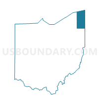
Sheff 2 Voting District, Ashtabula County, Ohio
About
Outline

Summary
| Unique Area Identifier | 642675 |
| Name | Sheff 2 Voting District |
| County | Ashtabula County |
| State | Ohio |
| Area (square miles) | 15.70 |
| Land Area (square miles) | 15.68 |
| Water Area (square miles) | 0.01 |
| % of Land Area | 99.92 |
| % of Water Area | 0.08 |
| Latitude of the Internal Point | 41.82952020 |
| Longtitude of the Internal Point | -80.65485570 |
Maps


Graphs
Select a template below for downloading or customizing gragh for Sheff 2 Voting District, Ashtabula County, Ohio


Neighbors
Neighoring Voting District (by Name) Neighboring Voting District on the Map
- Denmark Voting District, Ashtabula County, OH
- Kings 1 Voting District, Ashtabula County, OH
- Kings 2 Voting District, Ashtabula County, OH
- Monroe 1 Voting District, Ashtabula County, OH
- Pierpont Voting District, Ashtabula County, OH
- Sheff 1 Voting District, Ashtabula County, OH
Top 10 Neighboring County Subdivision (by Population) Neighboring County Subdivision on the Map
- Monroe township, Ashtabula County, OH (2,381)
- Kingsville township, Ashtabula County, OH (1,766)
- Sheffield township, Ashtabula County, OH (1,639)
- Pierpont township, Ashtabula County, OH (1,285)
- Denmark township, Ashtabula County, OH (946)
Top 10 Neighboring Unified School District (by Population) Neighboring Unified School District on the Map
- Conneaut Area City School District, OH (14,670)
- Buckeye Local School District, OH (12,625)
- Jefferson Area Local School District, OH (11,576)